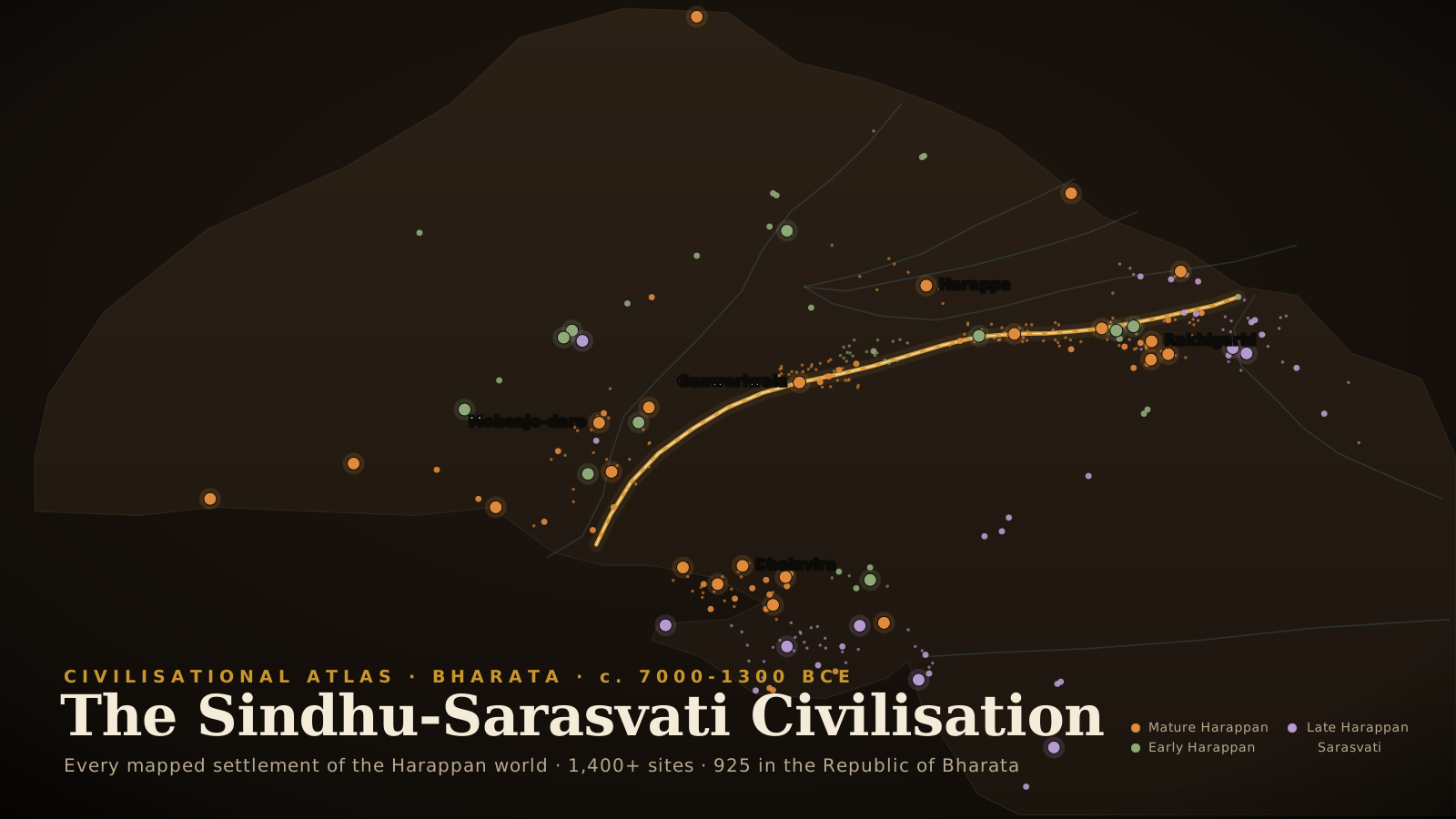
I. The Man Who Was Not There
The gnats came up off the swamp at dusk, and the villagers warned him about them before he climbed.
It was 1829. The man ascending the circular mound behind the ruins called himself Charles Masson and said he was an American. Both statements were false. He was James Lewis of London, born in 1800, and two years earlier he had walked out of the East India Company's artillery camp at Agra in the dark with one companion and had not gone back. Desertion carried the rope. He had been moving west ever since, through country the Company did not yet hold, learning Persian, collecting coins, sleeping in serais, becoming by slow degrees the scholar he would be remembered as rather than the fugitive he was.
From the summit there was room for the whole party and the horses. He turned and looked north across the plain.
What he saw was brick. Brick to the horizon in the failing light, tumbled and heaped and half-swallowed by earth, the remains of walls standing to the height of a man in places and elsewhere reduced to a scatter of fragments through which the grass came up. A ruinous castle of baked brick, its towers decayed but still legible as towers. And around it, spreading out under the pipal trees that grew thick over the whole area, the unmistakable footprint of something enormous.
The villagers had a figure for it. They told him the old city had run thirteen kos, and thirteen kos is twenty-five miles.
Masson stood on four and a half thousand years of buried civilisation and worked out, carefully and with real learning, that he was looking at the wrong thing.
Arrian had described Alexander's siege of Sangala among the Kathaioi: a brick fortress, a lake or swamp at the north-eastern angle, a mound defended by a triple line of chariots, a trench between mound and fortress. Masson checked each condition against the ground in front of him and found every one fulfilled. He wrote it down. Thirteen years later, in London, Richard Bentley published it in Narrative of Various Journeys in Balochistan, Afghanistan and the Panjab, and the first written notice of the largest civilisation of the ancient world entered the European record as a footnote to a Greek campaign that had missed it by two thousand years.
He was not a fool. He was among the most capable observers of his generation, the man whose coin-collecting opened the Bactrian Greek and Kushan dynasties to modern study and who did serious work toward the reading of Kharoshthi. He looked at the evidence with care and reasoned from it correctly.
He simply had no category in which the true answer could exist.
The information was there. The villagers had it, and gave it to him freely. What was missing was a world in which a planned city could stand in the Panjab a thousand years before the Buddha.
The mound was Harappa.
II. How a City Turns Into a Hill
Before any of what follows can make sense, one question has to be answered, and it is the question every visitor to these sites asks first: how does a city the size of a modern town disappear so completely that the people farming its roof do not know it is beneath them?
The answer is not conquest. It is not catastrophe. It is mud, and it is arithmetic.
A Harappan house was built of brick, and the brick was river silt. Sun-dried mud brick for interior walls and for most construction in the early centuries; fired brick, kiln-baked to a hard red, for foundations, drains, wells, bathing floors and outer faces in the mature cities. Both begin as the same alluvium the river lays down every flood season, and both, left to themselves, go back to it.
A mud-brick wall on the Panjab plain has a working life of perhaps thirty to sixty years. Monsoon damage undercuts it. Salt migrates up through it from the soil and blows the face off. The ground settles. At some point the house becomes unsound, and the householder faces a decision that every householder in every mud-brick civilisation on earth has faced and answered the same way.
He does not demolish to ground level. That is enormous labour for nothing. He knocks the walls inward, into the shell of the house, spreads the rubble flat, tamps it down, and builds again on top.
The new floor is now half a metre above the old one.
Do that continuously for seven hundred years across a city of forty thousand people and the arithmetic becomes something else entirely. At Mohenjo-daro the accumulated deposit of collapsed and rebuilt city runs to more than twelve metres in places. Twelve metres is a four-storey building, and all of it is city, laid down layer on layer, each floor sealing the one beneath.
The lowest levels of Mohenjo-daro have never been seen. Since antiquity the water table has risen, and the earliest occupation now lies below it. Marshall's teams pumped and failed. A century later it has still not been done. The bottom of the largest excavated city of the Sindhu-Sarasvati world remains, in the most literal sense, unknown, and the problem is hydrological rather than archaeological.
Then the plain itself rises to meet the mound. The Sindhu and its tributaries carry among the heaviest sediment loads of any river system on earth, and every inundation spreads a film of silt across the floodplain. Over four thousand years the ground surface of Sindh and the Panjab has climbed by metres. Sites that once stood proud are now waist-deep in alluvium; some are entirely beneath the modern surface, invisible until a canal is cut or a well is sunk or a tube-well boring brings up potsherds from nine metres down.
And then, for three thousand years, people quarried it.
A mound of hard, well-fired ancient brick standing in an alluvial plain that contains no stone whatsoever is not a ruin to a village builder. It is a quarry, the only one for a hundred miles. The mounds of the Panjab and Sindh were mined for house walls, field boundaries, well linings, the plinths of later temples and later mosques, generation upon generation. By the time Masson arrived, Harappa's upper levels had already been substantially carried away by the people of Harappa village.
That quarrying is precisely why anyone noticed. The robbing opened windows into the mounds and scattered ancient brick across the surface where it could be seen. The civilisation announced itself through the material stolen from it.
III. Ninety-Three Miles of Ballast
In 1856 the railway came, and with it the single greatest act of destruction in the history of Indian archaeology.
The East India Railway Company was driving track through the Panjab, Lahore toward Multan, and northward from Karachi. The chief engineers on these sections were two brothers, John and William Brunton, and they had a problem that anyone who has stood on that plain will understand immediately.
Railway track requires ballast. Beneath the sleepers must go a bed of hard, angular, sharp-edged stone that drains water and locks together under load. For six hundred kilometres in every direction from their alignment there was not one stone. Only silt, and silt, and silt.
John Brunton solved it first. Local people told him of a ruined city near his line called Brahminabad. He rode out to look, walked over it, and found the whole site made of hard well-burnt brick lying loose in enormous quantity. He was convinced, in his own recorded phrase, that here was a grand quarry for the ballast he wanted.
Brahminabad was reduced to ballast.
A few months later and further north, William Brunton's section ran close to another ruined city, from which, as he noted, the villagers of the adjacent settlement had already been helping themselves for years. His workmen went in with picks and baskets. The brick came out by the ton, was broken to size, and went under the rails.
By William Brunton's own account, that brick ballasted ninety-three miles of the line from Karachi to Lahore.
The village was Harappa.
A hundred and fifty kilometres of imperial railway rests on the pulverised fabric of one of the oldest cities on earth.
It is usually told as an anecdote, a piece of colonial-era colour. It deserves to be told as what it was. Fired brick from the mature phase of a four-and-a-half-thousand-year-old planned city, with every wall, drain, platform and floor in its original stratigraphic relationship, and every object sealed within those layers, was systematically dug out, smashed, mixed, carted and spread under a railway. The upper levels of Harappa did not survive. Whatever they held is not merely lost but unrecoverable, because the destruction took everything down to depth across the worked areas and the rubble was homogenised in the process.
When Alexander Cunningham came back to Harappa in 1872, having first seen it nineteen years before, he found the site he remembered largely gone. He recorded the disappointment plainly. The contractors had been there.
There is nothing to weigh here and no second reading to offer. The engineering priorities of the colonial administration were served by the destruction of the physical record of Bharata's oldest civilisation, and the destruction proceeded unopposed because no one in that administration attached any value to what was being destroyed. Settled The Bruntons wrote it down themselves.
IV. The Seal Cunningham Could Not See
Alexander Cunningham founded the Archaeological Survey of India in 1861 and became its first Director-General. He was a formidable field surveyor, and he did more than any man of his century to recover the physical geography of Buddhist Bharata, using Faxian and Xuanzang as field guides and walking the routes they walked.
That method was his strength, and at Harappa it blinded him completely.
He visited in 1853, again in 1856, and returned to dig in 1872-73. He was looking for a Buddhist site, because the framework he had inherited held that Bharata's urban history began with the historical period, and a mound of that size in the Panjab ought therefore to be Buddhist. He found the place quarried to pieces. He dug a little. And among the few things he recovered was an object that should have stopped him where he stood.
A seal. Steatite, small enough to sit in a palm, cut in intaglio. On it a humped bull, and above the bull six characters in a script that was not Brahmi, not Kharoshthi, not anything he had seen in a lifetime of reading Indian inscriptions.
He published it. And then he explained it away: the seal must be foreign to Bharata, an import, because no Indian script of that form existed.
The single most important artefact class of the oldest civilisation of Bharata lay in the hand of the head of the Archaeological Survey, and the interpretive frame available to him made it, of necessity, not Indian.
This reflex recurs so often in the next century and a half that it is worth naming at its first clean appearance. When something in the material record of Bharata proves older, larger or more original than the governing framework permits, the framework's first move is to assign it elsewhere: to import, to migration, to external influence. Cunningham's seal is the earliest documented instance. It required no bad faith. It only required a discipline whose founding assumptions were colonial and which had not yet been given cause to test them.
Fifty years passed. The seals accumulated in Survey drawers, unread and unplaced, waiting for a change in who was doing the looking.
V. Sahni Opens the Ground
The change, when it came, came in the person of a Sanskritist from a small town in the Panjab.
Rai Bahadur Daya Ram Sahni was born at Bhera in 1879. He trained in Sanskrit before entering the Archaeological Survey, and he had already made one discovery that would outlive him: at Sarnath, he uncovered the lion capital of Ashoka's pillar, the sculpture that independent Bharata would take as the emblem of the Republic.
The man who found the Lion Capital is the man who opened Harappa. That sentence should be better known than it is.
The prompt came from another Indian. Hiranand Sastri surveyed the site for the Survey and reached the conclusion that had escaped Cunningham for two decades: whatever this was, it was not Buddhist, and if it was not Buddhist it was older than the framework allowed. On that report, the Director-General, Sir John Marshall, assigned Sahni to excavate the two principal mounds.
The first season ran through the winter of 1920 into 1921. Sahni cut into Mound AB and Mound F. Out of the trenches came seals of the type Cunningham had dismissed. Painted pottery of a tradition no one could place. Chert blades struck from prepared cores. Terracotta. Beads of carnelian and steatite.
Marshall's first report on the Harappa excavations was published on 29 March 1921, which is why that year stands as the beginning.
The Survey's accounts register how fast the significance landed. One season's expenditure at Harappa: three thousand rupees. The next: thirteen thousand. By the 1924-25 season the work was being supported by an aeroplane survey flying some fifty miles along the abandoned bed of the Ravi on which Harappa stands, among the earliest uses of aerial reconnaissance anywhere in Indian archaeology.
VI. The Mound of the Dead Men
Six hundred kilometres south, in Sindh, there was a mound the local people had named a long time ago and named accurately.
Mohenjo-daro. The mound of the dead men.
A Kushana-period Buddhist stupa stood on its summit, and that stupa was the only reason the site had ever drawn official attention. D. R. Bhandarkar had come in 1911 and gone away again. The place was a Buddhist ruin sitting on a hill, and no one had asked what the hill was made of.
Rakhal Das Banerji asked.
Banerji, Rakhaldas Bandyopadhyay, was born at Berhampore in Bengal in 1885, took his degree at Calcutta, joined the Survey and rose to Superintending Archaeologist of the Western Circle. He was deputed to Mohenjo-daro in 1919, the second Survey officer to look at it, and he returned in the 1922-23 season with men and tools to dig.
He cut below the stupa and around it, and he found that the hill was a city.
And then he found the thing that mattered more than the city. In the deposits under the stupa were seals. Square, steatite, intaglio-cut, animal above a line of unreadable signs.
They were the same seals Sahni was pulling out of the ground six hundred kilometres away in the Panjab.
Two cities, six hundred kilometres apart, sharing a script, a seal tradition, a brick standard and a material culture, are not two sites. They are one civilisation. That recognition is the discovery, and an Indian made it, in a letter, in 1923.
Banerji wrote to Marshall in 1923 proposing the remote antiquity of Mohenjo-daro and, by implication, of the whole culture. He was the first person on earth to understand what had been found.
What became of Banerji's report
In 1926 Banerji submitted his report on the Mohenjo-daro excavations to Marshall, for publication by the Government of Bharata's Department of Archaeology.
It was not published.
Four years later, in 1930, he received back a typed copy with a letter informing him that the Department could not publish it and that he was at liberty to publish it separately. Marshall retained the original, with its photographs and its illustrations.
In 1931 Marshall published his own three volumes, Mohenjo-daro and the Indus Civilization.
Banerji had by then left the Survey for the Manindra Chandra Nandy chair of Ancient Indian History at Banaras Hindu University. He died in 1930, aged forty-five, and never saw his report in print. It did not appear in his lifetime. The original was not returned. Settled
Marshall did acknowledge him, in the introduction to his own volumes, writing that to the late Mr R. D. Banerji belongs the credit of having discovered, if not Mohenjo-daro itself, then at any rate its high antiquity. Read that sentence again and watch the qualification do its work. It concedes the insight and withholds the site.
The Survey's convention was that officers reported inward and the Director-General synthesised and published outward. That was the system, and the system was not neutral in its operation. It carried credit upward and westward, out of the hands of the Indian archaeologists who were standing in the trenches and into the hands of the British administrator who was not. The public record that emerged named Marshall as the discoverer of a civilisation that two Indians had excavated and one of them had identified. Polemical
VII. A Forgotten Age Revealed
On 20 September 1924, readers of The Illustrated London News opened their weekly to a headline that ran: A Forgotten Age Revealed.
Marshall had written it. He laid out the finds from Harappa and Mohenjo-daro, credited Sahni and Banerji as the excavators working under Survey supervision since 1921 and 1922, and reached for the only comparison his readership would feel in the stomach: Schliemann at Tiryns and Mycenae, the archaeologist breaking ground and bringing up a forgotten world.
The captions of that issue are a document in themselves. The prehistoric buildings at Mohenjo-daro were dated, in print, to probably between 1000 and 400 BCE. The remains were described as older than anything yet known in Bharata, which was true, and as pushing back the earliest known Indian civilisation by several centuries, which understated the case by roughly two thousand years.
Then Marshall did something genuinely scholarly. He asked his readers for help in dating the material.
The reply came fast. Professor A. H. Sayce of Oxford wrote in to point out that the Indus seals had parallels in Mesopotamia. Others followed. Within months, seals of unmistakably Indus type were being identified in dated Mesopotamian levels, in contexts associated with the Akkadian period, and the whole chronology fell backward through two thousand years like a floor giving way.
These cities were not Iron Age. They stood while Sargon of Akkad reigned and while the Old Kingdom raised the pyramids at Giza.
Method: cross-dating. Before radiocarbon existed, the only way to place an undated culture in absolute time was to find its objects inside somebody else's dated stratigraphy. Indus seals and Indus carnelian beads sitting in Mesopotamian levels of known date gave this civilisation its first anchor in real time. Mesopotamian tablets recording trade with a distant eastern land called Meluhha supplied a plausible name for it. Radiocarbon after 1949, and later AMS and OSL dating, confirmed and refined the picture. But the first leap was made by matching a seal to a foreign archive.
The framework that swallowed the discovery
Marshall's article did not land in an empty world. It landed in a colonial Bharata whose governing historical framework had been built over the preceding century largely by British Indologists and philologists, and that framework held that Indian civilisation began with an incursion of light-skinned Aryans from outside, who brought the Vedas to a subcontinent of primitives.
The utility of this was not subtle. It made the British the most recent in a long line of civilising foreign arrivals, and it installed a permanent fracture line down the middle of Indian society for the administration to work with.
A pre-existing urban civilisation in the northwest ought to have tested that framework to destruction. Instead it was conscripted into it within a decade. The story hardened into a formula that is still recited: dark indigenous city-builders, destroyed by fair Aryan invaders arriving with horses and chariots.
Not one element of that formula came from the archaeology. It was a literary reading of the Rigveda, projected onto a material record that had barely been scratched, and it was picked up almost immediately by movements with a direct interest in a racial account of Indian society. It remains the load-bearing premise of a great deal of political argument in Bharata today. Polemical
One magazine article, carrying a chronology wrong by two millennia, seeded a framework that has outlived every specific claim used to build it.
VIII. How the Ground Is Read
Between Marshall's announcement and the present lies a century of method, and the method is where the discipline actually lives. Most of archaeology is not digging. Most of archaeology is finding sites without touching them, because the one thing every excavator knows is that a trench, once opened, can never be opened again.
Walking
The oldest technique and still the one that has found the most. Field walkers cross the landscape in transects at fixed spacing, heads down, recording everything on the surface. The signature of a Harappan site, once learned, is unmistakable: fragments of fired brick in a standard proportion, red-slipped pottery painted in black, chert blade debris struck from prepared cores, broken terracotta bangles, occasionally the glint of a carnelian bead or a chip of steatite.
Muhammad Rafique Mughal walked the dry bed of the Hakra through Cholistan in the 1970s and 1980s, season after season, and added hundreds of sites to the record. The Archaeological Survey and the state departments did the same work eastward across Haryana, Panjab and Rajasthan. Between them they transformed the demography of the civilisation from a handful of cities into a landscape of settlement.
Excavation destroys what it examines. Every layer removed is gone permanently, and everything not recorded at the moment of removal is lost. Survey costs almost nothing and destroys nothing, and it produces the regional picture that no amount of digging in one place can give. A single excavated city yields a city. A survey yields a civilisation.
Looking down
Aerial photography, satellite imagery, terrain models. Buried structures change what grows above them. A wall holds less moisture, so the crop over it ripens early and yellows: a parch mark. A ditch or a filled pit holds more, so the crop stands taller and greener: a crop mark. Invisible from the ground, obvious from the air.
For this region the decisive application has been palaeochannel mapping. Landsat, IRS and SRTM data have traced a web of abandoned river courses across the Sutlej-Yamuna interfluve running to some eight thousand kilometres of channel, of which the Ghaggar-Hakra system accounts for roughly two thousand two hundred. Plotting the known sites against those channels produced the single most consequential distributional fact in the field.
Reading the field without opening it
Magnetometry measures minute variations in the earth's magnetic field. Fired material, kilns and hearths and burnt brick, is strongly magnetic; a ditch filled with topsoil reads differently from undisturbed subsoil. A magnetometer walked over a buried town in a few days will produce its street plan.
Ground-penetrating radar pulses radio waves downward and times the return, adding the depth that magnetometry cannot give. Electrical resistivity passes current between probes: walls resist, ditches conduct.
Accident
Which in Bharata remains a leading cause of discovery. Canal cutting, tube-well boring, brick-kiln clay extraction, road building, ploughing, flood scour. Sanauli in Baghpat district, with its coffin burials and its copper antenna swords, came to notice in 2005 when a brick kiln dug into burials. The district gazetteers are full of such reports, and a substantial fraction of the known sites entered the record exactly this way: a farmer deepens a channel and turns up brick of an unfamiliar size.
The names on the map
Village names, revenue records, local memory. A mound called Dheri or Theh or Garhi in a settlement's revenue map is a lead worth following. As at Harappa in 1829, the people living on a site very often know that it is one.
IX. Anatomy of a Trench
What follows is the working vocabulary of the discipline, and the sequence of an excavation from permission to publication.
In Bharata, digging requires a licence from the Archaeological Survey under the Ancient Monuments and Archaeological Sites and Remains Act. A research design must be submitted: what question is being asked, why this site answers it, what will be opened, and increasingly what will deliberately be left untouched. Funding, storage, conservation provision and a commitment to publish are all part of the application.
Then the site is gridded. A datum is fixed and surveyed to a known elevation. The site is laid out in squares, commonly ten metres by ten, subdivided into five-metre units, aligned to the cardinal points and lettered and numbered, so that every object recovered can be placed in three dimensions.
Working vocabulary of excavation
| Term | Meaning |
|---|---|
| Trench | The excavation unit itself, defined by the grid |
| Baulk | The unexcavated strip left standing between trenches; its vertical face preserves the full layer sequence |
| Section | The vertical face showing strata in profile; a section drawing is a measured scaled record of it |
| Plan | The horizontal record, what is visible looking down at a given stage |
| Context | The fundamental recording unit: one distinguishable deposit, cut or structure |
| Cut | A negative feature, the act of removal: a pit, posthole, grave or robber trench |
| Fill | Whatever accumulated in a cut afterwards |
| Interface | The surface between two contexts; often the most informative thing on a site and the hardest to see |
| Feature | A non-portable constructed element: hearth, drain, wall, oven, platform, altar |
| Small find | An object judged individually significant, recorded with full three-dimensional coordinates |
| Bulk find | Material recorded by context rather than individually: sherds, bone, brickbat |
| In situ | In original position, undisturbed; the condition that makes an object informative |
| Spit | An arbitrary horizontal level removed when natural layers cannot be distinguished; a last resort |
| Sondage | A small deep trench cut to establish the sequence before committing to open-area work |
| Natural | The sterile deposit below all human activity |
Two ways to dig
Sir Mortimer Wheeler arrived as Director-General of the Archaeological Survey in 1944 and brought with him a rigorously stratigraphic method refined in Britain. The site is dug in a grid of squares separated by standing baulks of unexcavated earth. Because the baulk faces expose the layers in section throughout the dig, the excavator checks the horizontal work against the vertical record continuously. Wheeler's 1946 season at Harappa established the fortification sequence and, more lastingly, demonstrated to a generation of Indian archaeologists whom he trained what controlled stratigraphic excavation looked like. The cost of the method is that the baulks conceal a substantial share of the site and sever the connections between features.
The modern alternative came out of British urban rescue work in the 1970s. Open-area excavation removes the baulks and opens everything. Each context is identified, planned, photographed, described on a context sheet and removed individually, in reverse order of deposition: the last thing laid down is the first thing dug.
With no permanent sections, the stratigraphic record has to be constructed entirely from relationships between contexts, and the instrument for that is the Harris Matrix, formulated by Edward Harris in 1979. Each context becomes a box; the lines between boxes record whether one lies above another, below it, or is contemporary with it. It renders the entire depositional sequence of a site of any complexity as a single readable diagram, and it is now the standard of the discipline.
The laws of archaeological stratigraphy. Superposition: in an undisturbed sequence, upper units are younger than lower ones. Original horizontality: deposits settle toward the horizontal, so a sharply tilted layer means deposition against a slope or later disturbance. Original continuity: a deposit originally extended until it thinned out or met a barrier, so an abrupt edge means something later cut it. Stratigraphic succession: a unit's place in the sequence is defined only by the units immediately above and below it.
These are borrowed from geology and adapted, and the adaptation matters. Human deposits are made deliberately and are cut into constantly, which is why the cut is such a central idea and why archaeological stratigraphy is far more disturbed than anything a geologist meets.
The work itself
Topsoil comes off, sometimes by machine under supervision. Everything below it is by hand. The instruments are a pointing trowel, a hand shovel, brushes, and for fine work dental picks and sharpened bamboo. The excavator works by following the layer: exposing the interface between one deposit and the next, watching and feeling for changes in colour, texture, compaction, inclusions. It is done kneeling, for hours, in heat.
All excavated soil is sieved, dry or wet, to catch what the eye misses. Flotation, in which soil is agitated in water so that carbonised plant material floats free into fine mesh, recovers seed and charcoal, and it is the foundation of archaeobotany. This is how the wheat, barley, millet, sesame, cotton and, at Rangpur and Lothal, rice of the Harappan agricultural economy were established.
Recording runs continuously and is the actual product of the exercise. Every context receives a sheet describing composition, colour against a Munsell chart, dimensions, relationships and finds. Every context is planned and photographed. Levels are taken from the datum. Increasingly the whole is captured in three dimensions by total station, photogrammetry and drone, producing a model of the site at each stage that can be revisited long after the deposit itself has gone.
Modern excavation removes far more than objects. Radiocarbon samples of charcoal, seed or bone collagen are sealed in foil from secure contexts. OSL samples, which date the moment a mineral grain was last exposed to sunlight, are hammered into a section face inside light-proof tubes. Blocks of undisturbed sediment are resin-impregnated and thin-sectioned for micromorphology, revealing trampled floors invisible in the field. Phytoliths and pollen for vegetation. Lipid residues absorbed into pot fabric, identifying dairy and animal fat and plant oil. Ancient DNA from petrous bone or tooth cementum, taken gloved and masked under contamination protocol. Strontium and oxygen isotopes from tooth enamel, which record where an individual spent childhood and so test mobility directly.
X. When the Digging Stops
There is a technical answer and there are practical ones, and the distance between them is where the discipline actually operates.
Technically, a trench is finished when it reaches natural: the sterile deposit below all human activity, confirmed by digging some way into it and finding nothing at all. No sherds, no bone, no charcoal, no cuts. At that point the sequence for that trench is closed and the full depth of the site is known there.
Practically, work stops for other reasons. The research question gets answered. The season ends, because fieldwork in Bharata runs roughly December to April and an open trench does not survive the monsoon. The money runs out, which is the most common reason anywhere on earth. A rescue window closes ahead of construction.
And, increasingly, because someone decides not to dig.
The governing ethic of the discipline is now that the best excavation is the one never carried out.
Because excavation is irreversible, current practice holds that a substantial portion of every site must be left in the ground, reserved for methods that do not yet exist. This is not timidity. Consider only what the last fifty years added: radiocarbon calibration, AMS, OSL, residue analysis, stable isotopes, micromorphology, ancient DNA. Every one of those can be applied to material still in the earth, and to none of the material carried away in baskets from Mohenjo-daro in 1925.
Rakhigarhi is the largest site of the civilisation, some three hundred and fifty hectares. Excavation there has run in 1963, from 1997 to 2000, from 2012 to 2016, and again from 2021. Only a small fraction has been touched. That is not neglect. Most of Rakhigarhi is being held deliberately for archaeologists not yet born.
Closing a trench
Final plans and sections are drawn, photographs taken, and the trench is either backfilled with its own spoil, often over a marker membrane so that a future excavator can distinguish modern fill from ancient deposit, or conserved for display: walls capped, surfaces consolidated, drainage cut, shelters raised.
Conserving exposed Harappan brick is a severe and largely unsolved problem. Brick that has been chemically stable underground for four thousand years begins to fail within years of exposure. The enemy is salt: groundwater rises through the fabric by capillary action, evaporates at the surface, and leaves crystals that expand and spall the face away course by course. Mohenjo-daro has been deteriorating since the day it was uncovered, and much of what a visitor sees now is stabilised or rebuilt fabric rather than original surface. Conservators have made the serious argument that excavating it at all was a net loss to knowledge.
The years after
Fieldwork is the short part. Post-excavation analysis runs three to five times as long.
Finds are washed, marked with site and context codes, catalogued. Pottery is quantified by fabric and form and built into a type series for relative dating. Specialists take their categories: animal bone to a zooarchaeologist, plant material to an archaeobotanist, human remains to a bioarchaeologist, metal to a metallurgist. Samples go to laboratories and return as determinations with error ranges, to be calibrated against the atmospheric curve. The Harris Matrix is finalised and contexts are grouped into phases. Then the report is written, with the full context register and finds catalogue, so that another archaeologist can re-analyse the site without re-digging it.
The publication record of Indian archaeology is uneven here, and it is a real wound. Significant excavations remain incompletely published decades on, surviving only as brief notices in Indian Archaeology: A Review. An unpublished excavation is very close to a destroyed one. The honourable counter-example, and the standard against which the rest should be measured, is R. S. Bisht's full report on Dholavira, covering thirteen seasons from 1989-90 to 2004-05 and published by the Survey in 2015.
XI. What They Built
The brick
The most eloquent artefact of this civilisation is not a seal or a statue. It is a brick.
Across an area larger than western Europe, for seven centuries, Harappan builders made fired brick in a fixed ratio of one to two to four: thickness to width to length. The common mature-phase size runs about seven by fourteen by twenty-eight centimetres.
That ratio is not decoration. A one-two-four brick can be laid in alternating courses of headers and stretchers so that every course interlocks and no vertical joint runs continuously through the wall. It is the strongest simple bond available to a mason, and it is what they used, systematically, from Sutkagan Dor on the Makran coast to Alamgirpur on the Hindon in the Ganga-Yamuna doab.
Consider what a standard brick over that distance requires. Standard moulds. Standard kiln practice. An agreed measure, held stable across generations and across a subcontinent. It means a builder trained in Sindh could take work in Gujarat and know the material before he saw it. It is the signature of a shared technical culture maintained across the whole of the northwest without, so far as anyone can demonstrate, an empire to enforce it.
The weights say the same thing. Cubical chert weights in a binary series, one, two, four, eight, sixteen, thirty-two, sixty-four, then multiplied by a hundred and sixty and running decimal above that, with the base unit around 13.6 grams. Weights recovered from sites hundreds of kilometres apart conform to the standard within a fraction of one per cent. Whatever this polity was, it held metrological discipline better than most states that came after it.
Water
Above everything else, these were hydraulic engineers, and here their achievement stands without parallel anywhere in the ancient world.
Every substantial house in the mature cities had access to water and a means of getting rid of it. Mohenjo-daro is estimated to have held seven hundred wells or more, each brick-lined with wedge-shaped bricks manufactured specifically for circular construction. Houses had bathing platforms, floors of brick laid so tightly that the joints are barely visible, sloped to a corner drain. Many had latrines. Waste ran through terracotta pipes or brick channels into covered street drains laid at a calculated gradient, fitted with inspection holes and settling traps to catch solids for cleaning, and carried out beyond the walls.
No other Bronze Age civilisation did this. Not Egypt, not Sumer, not Minoan Crete. Comparable urban sanitation does not appear again anywhere on earth until Rome, and does not become ordinary in European cities until the nineteenth century of the common era.
Dholavira, and the invention of rainwater harvesting. Dholavira stands on Khadir island in the Rann of Kutch, a place with no perennial river and almost no rain. Bisht's thirteen seasons revealed how it survived. At least sixteen reservoirs, occupying a large share of the walled area, cut down into living rock and faced with dressed stone, the largest around seventy-three metres long and twenty-nine wide. Two seasonal streams, the Manhar and the Mansar, were dammed and channelled inward. Roof and street runoff was gathered through drains high enough for a man to walk upright. The whole system was arranged so that the overflow of one reservoir fed the next.
Dholavira is unique too in its plan, divided into castle, bailey, middle town and lower town, and in its use of dressed stone rather than brick, since Khadir has stone and little fuel for kilns. It quarried and exported worked sandstone as far as Harappa and Mohenjo-daro, hundreds of kilometres away.
The Great Bath
On the citadel mound at Mohenjo-daro is a tank about twelve metres long, seven wide and two and a half deep, with brick steps descending at each end.
Its construction is emphatic to the point of obsession. Brick set in gypsum mortar, fitted so closely the joints hold no water; behind that a damp-proof course of bitumen; behind that more brick. It was built to hold water and to stop that water reaching the platform beneath. A well fed it. A corbelled drain emptied it. Around it run a colonnade and a series of small chambers.
Marshall read it as a tank for ritual bathing, and the reading has never been seriously displaced. There is no evidence for a swimming pool, no evidence for a reservoir, and its waterproofing goes far beyond anything storage would require. Its position on the citadel, among structures that are plainly not domestic, argues purpose rather than utility.
Ritual bathing, in a constructed tank, reached by steps, within a raised sacred precinct, with small chambers around it. Anyone who has walked down the steps of the temple tank at Madurai or Kumbhakonam has moved through an architectural form that was already standardised at Mohenjo-daro four and a half thousand years ago. Settled on the archaeology; Contested only in how directly the line of transmission may be drawn.
The seals and the silence
Around four thousand inscribed objects are known, most of them square steatite seals two to four centimetres across, cut in intaglio and fired to harden and whiten the surface, with a pierced boss on the reverse for a cord. A typical seal carries an animal in profile above a short line of signs.
The commonest animal is a single-horned creature, conventionally the unicorn, standing before an object usually described as a manger or a ritual stand. After it come the humped zebu bull, the short-horned bull, the elephant, the rhinoceros, the tiger, the buffalo, and composite creatures that exist nowhere in nature.
The script runs to roughly four hundred signs, more if variants are counted separately. The inscriptions are short: five signs on average, seventeen on the longest single surface. It was written right to left, as the cramping at the left edge of crowded seals demonstrates.
It has not been read. The reason is structural rather than a failure of ingenuity: there is no bilingual text, no long inscription, and no knowledge of the underlying language. Claimed decipherments appear every few years and none has achieved acceptance. Settled The further claim, made by some scholars from sign-frequency statistics, that it is not writing at all, is disputed on the same statistical ground. Contested
The seated figure
Seal 420 from Mohenjo-daro shows a figure seated on a low platform. The legs are folded with the heels drawn together and the knees pressed outward. The arms extend to rest on the knees. The head carries a horned headdress. Around the figure stand an elephant, a tiger, a rhinoceros and a buffalo, with deer beneath the seat.
Marshall called it a proto-Shiva, reading the animals as pashu and the figure as their lord, and resting his case on the posture, the animals, the horns and what he took to be three faces.
The identification has been argued over for a century. Sceptics note that the faces may be a stylised headdress, that seated figures among animals occur elsewhere in West Asian art, and that reading a specific later deity into a Bronze Age image is methodologically hazardous. Contested
What is not seriously contested is the posture. The figure is sitting in a recognisable asana: the arrangement of the folded legs, the hands laid on the knees, the spine held erect. Whatever else it is, it is doing the thing the tradition of this land calls sitting for meditation, and doing it in a form transmitted without interruption from that day to this. Terracotta figurines from Harappa and elsewhere show comparable postures, some with the palms joined at the chest.
Fire
At Kalibangan, on the Ghaggar in Rajasthan, the excavations of B. B. Lal and B. K. Thapar from 1961 uncovered on the citadel mound a row of seven rectangular pits, brick-lined, filled with ash and charcoal, each holding a vertical clay stele, a central upright, with terracotta cakes among the ash. Similar installations appeared in domestic contexts in the lower town, and comparable ones at Lothal, Banawali, Rakhigarhi and Kanmer.
Fire installations, in a row, on a raised platform, with a central upright, carrying ash, in both civic and household settings, sustained across a civilisation and across centuries. Many Indian archaeologists identify them with agnikunda practice. Others prefer to call them hearths of undetermined function. Contested
Two observations sharpen the question considerably. They are not cooking hearths: they hold no food residue and none of the animal bone that kitchen fires produce, and a formal row on a platform is not how anybody cooks. And Kalibangan produced something else, in the levels beneath the mature city: a preserved ploughed field, the earliest known anywhere on earth, its two sets of furrows crossing at right angles. That is the classic technique for growing two crops in one field simultaneously, and farmers in northern Rajasthan still plough that way.
Principal excavated sites and their signature evidence
| Site | Location | Excavator and date | Signature |
|---|---|---|---|
| Harappa | Sahiwal, Panjab | Daya Ram Sahni 1921; M. S. Vats; Wheeler 1946 | Type site; granary; cemeteries R-37 and H |
| Mohenjo-daro | Larkana, Sindh | R. D. Banerji 1922; Marshall; Mackay | Great Bath; some 700 wells; 12 m deposit; seal 420 |
| Rakhigarhi | Hisar, Haryana | Suraj Bhan 1963; Amarendra Nath 1997-2000; Shinde 2012 onward | Largest site, c. 350 ha; cemetery; first ancient DNA |
| Dholavira | Kutch, Gujarat | J. P. Joshi 1967-68; R. S. Bisht 1989-2005 | Sixteen reservoirs; four-part plan; the signboard |
| Kalibangan | Hanumangarh, Rajasthan | B. B. Lal and B. K. Thapar 1961-69 | Fire altars; earliest ploughed field; on the Ghaggar |
| Lothal | Ahmedabad, Gujarat | S. R. Rao 1954-62 | Dockyard basin; bead factory; warehouse |
| Banawali | Fatehabad, Haryana | R. S. Bisht 1974 onward | Fire altars; apsidal structure; terracotta plough |
| Bhirrana | Fatehabad, Haryana | L. S. Rao 2003-06 | Earliest dated levels in the sequence; Hakra ware |
| Sanauli | Baghpat, Uttar Pradesh | D. V. Sharma 2005; S. K. Manjul 2018 | 125 burials; wooden coffins; cart burials; antenna swords |
| Mehrgarh | Kachi, Baluchistan | J.-F. Jarrige 1974-86 | Farming village from c. 7000 BCE; drilled teeth |
| Bhagwanpura | Kurukshetra, Haryana | J. P. Joshi 1975-76 | Late Harappan and Painted Grey Ware overlap |
| Shortugai | Takhar, Afghanistan | H.-P. Francfort 1976-79 | Trading colony on the Oxus; lapis lazuli source |
XII. The Size of It
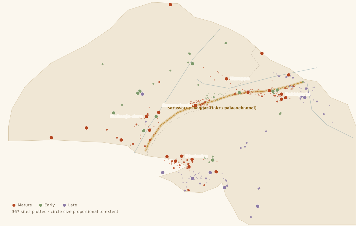
FIGURE: distribution map of the Sindhu-Sarasvati world. 367 plotted sites across undivided Bharata, phase-coloured, with the Sarasvati (Ghaggar-Hakra) palaeochannel in gold and the 1947 line shown faintly as annotation. The concentration along the dry Sarasvati bed is the argument of Part XIII made visible.
Comparative extent of the three great Bronze Age civilisations
| Civilisation | Approximate area at peak | Urban florescence |
|---|---|---|
| Sindhu-Sarasvati | 1,250,000 to 1,500,000 sq km | c. 2600-1900 BCE |
| Egypt, Old Kingdom | c. 40,000 sq km | c. 2686-2181 BCE |
| Sumer and Akkad | c. 65,000 sq km | c. 2900-2000 BCE |
More than fourteen hundred sites have been recorded. Of these, nine hundred and twenty-five lie within the Republic of Bharata and four hundred and seventy-five in Pakistan, with a handful in Afghanistan understood as trading colonies. Some counts run past two thousand, depending on what is admitted as a site. Around eleven hundred of them, roughly four in every five, lie on the plains between the Sindhu and the Ganga systems.
Fewer than a hundred have been excavated to any degree at all.
Five sites qualify as major urban centres: Mohenjo-daro, Harappa, Ganweriwala, Dholavira and Rakhigarhi. Two of the five are in Bharata. The largest of the five, Rakhigarhi, is in Haryana. The earliest dated levels in the entire sequence, at Bhirrana, are also in Haryana.
At its greatest extent the civilisation ran from Sutkagan Dor on the Makran coast near the Iranian frontier to Alamgirpur on the Hindon in Uttar Pradesh; from Manda on the Chenab in Jammu down to Daimabad on the Pravara in Maharashtra; with the outpost of Shortugai on the Oxus in Afghanistan, eight hundred kilometres beyond the northern edge, planted there to work the lapis lazuli of Badakhshan.
This is not the Indus Valley. It is a subcontinent.
The name Indus Valley Civilisation is a historical accident compounded by a geographical error. Harappa became the type site because it happened to be dug first. The valley of the Sindhu gave the name because the first two cities came out of it. Neither survives contact with the distribution map. Most of the sites are not in the Indus valley, and the densest concentration of them lies along another river system altogether.
XIII. The River That Went Away
Plot the sites on a map and something declares itself immediately.
A dense belt of settlement runs out of the Shivalik foothills, down through Haryana and northern Rajasthan, and on into Cholistan, following a channel that is dry for most of the year and in stretches entirely buried under sand. The Ghaggar in Bharata; the Hakra across the line in Pakistan; running on toward the Nara in Sindh.
Mughal walked that bed through Cholistan and found site after site strung along it like beads on a cord. The Indian surveys found the same thing on the eastern side. This is not a marginal concentration. This is where most of the civilisation lived. Settled
And the tradition of this land has always known what that river was.
The Rigveda names the Sarasvati more often than any river except the Sindhu, and gives it praise it gives to nothing else: ambitame nadītame devitame sarasvati, best of mothers, best of rivers, best of goddesses. It is described flowing from the mountain to the sea. The nadistuti hymn places it, unambiguously, between the Yamuna and the Sutlej. And the later texts, the Brahmanas and the Mahabharata, record it diminishing, failing, and at last vanishing into the sand at Vinashana.
The Ghaggar-Hakra lies exactly between the Yamuna and the Sutlej. It disappears into the Thar. The identification was proposed in the nineteenth century and is the plain reading of the geography. Settled that the tradition locates the Sarasvati there. Contested what was flowing in it, and when.
The objection, at full strength
Honest work requires stating the counter-case at its strongest, and the counter-case here is serious.
Clift and colleagues, in 2012, used uranium-lead dating of zircon grains to fingerprint the sources of sediment in the channel, and concluded that the Yamuna ceased to feed the Ghaggar system very early indeed, possibly around fifty thousand years ago, and that the Sutlej diverted away before roughly ten thousand years ago. Ajit Singh and colleagues, in 2017, using OSL chronologies, agreed that the Sutlej abandoned the channel some eight thousand years back, well before the mature cities were built.
Their conclusion was arresting: that it was the departure of the great river, leaving behind a stable, flood-free, monsoon-fed channel, that made dense settlement possible in the first place. On this reading the Harappans settled the Ghaggar because the big river had already gone.
This cannot be waved away, and Dhara will not attempt it. If the analysis holds, the river beside which most of these people lived was seasonal and monsoon-fed rather than perennial and glacier-fed.
What survives it
Five things, and they carry the argument.
The channel existed and it carried water. Nobody disputes that the Ghaggar-Hakra was a functioning river system through the Harappan centuries, with associated lakes and ponds; the OSL work itself confirms it. The dispute is about the source and the volume, never the existence.
The monsoon was far stronger. Palaeoclimate reconstruction is agreed that the early and middle Holocene monsoon over the northwest was substantially wetter than today's, weakening progressively from around four thousand years ago. A monsoon-fed Ghaggar in 2600 BCE was not the Ghaggar anyone sees now.
The dating is not closed. The palaeochannel network is vast and multi-phase, and different studies sample different channels. Which of those eight thousand kilometres of mapped channel corresponds to which river at which date remains genuinely unsettled, and geomorphologists including K. S. Valdiya have argued for later Himalayan connections on independent grounds. Contested
The collapse still tracks the water. Whatever fed the system, it failed, and the abandonment of the Sarasvati belt around 1900 BCE coincides with that failure and with the weakening of the monsoon. The causal account of what ended the cities is untouched by the dispute.
And the tradition itself describes a river that shrank. It does not describe a permanent torrent. It describes greatness, then diminishment, then disappearance into sand, which is precisely the sequence the geology reconstructs. The texts of this land recorded the death of a river, and they recorded it accurately.
The case for naming this the Sindhu-Sarasvati civilisation does not depend on settling the geology. It rests on the distribution: the majority of sites lie along the Ghaggar-Hakra, and a civilisation is properly named for where its people actually lived. Indus Valley describes a minority of the sites. Harappan names the whole after whichever village a British engineer reached first.
That the people of this land have called that river the Sarasvati for three thousand years and have remembered losing it is not sentiment to be set aside in favour of a zircon analysis. It is testimony, and the geology does not contradict it. The geology disputes the river's source. It does not dispute its identity, and it confirms its disappearance.
XIV. The Invasion That Never Happened
In 1947 Mortimer Wheeler wrote a sentence that governed the popular understanding of Indian antiquity for the next fifty years. Noting that the Rigveda calls Indra purandara, breaker of forts, and pointing to groups of skeletons recovered from the upper levels of Mohenjo-daro, he concluded that Indra stood accused.
The case ran: the cities fell suddenly; bodies lay unburied in the streets, some bearing weapon wounds; a warlike people came in from the northwest with horses and chariots; the Rigveda sings of forts destroyed. Therefore an Aryan invasion destroyed the cities of the Indus.
Every element of it has failed.
The skeletons. George Dales re-examined the remains and published the result under a title chosen to leave no ambiguity: The Mythical Massacre at Mohenjo-daro, 1964. The bones come from different stratigraphic levels spanning a considerable period. Several were in proper burials. Some lay in levels that post-date the abandonment of the areas concerned. The supposed weapon injuries were re-examined as post-mortem damage or as disease. There is no single event, no battle deposit, no massacre. Settled
The destruction layer. This is the decisive point and it deserves stating flatly. When a city is stormed and burnt it leaves an unmistakable signature that archaeologists find routinely at Troy, at Hattusa, at Ugarit, at Lachish: a continuous burnt horizon running across the site, collapsed superstructure, weapons lying in the destruction deposit, bodies in the collapse, valuables abandoned where they fell.
No Harappan city has one. Not Mohenjo-daro, not Harappa, not Kalibangan, not Dholavira, not Rakhigarhi. No burnt horizon. No weapons cache. No arrowhead scatter. No last stand. Settled
The fortifications. The cities had walls, but those walls read far more convincingly as flood defence and administrative boundary than as military works. They lack ditches, complex gate-traps, and the bastion spacing that enfilading fire requires. And in a century of excavation the civilisation has produced no weapons assemblage worth the name: no swords in quantity, no armour, no military iconography.
What the ground shows instead. Between roughly 2000 and 1700 BCE the large sites of the Sarasvati belt and the Sindhu valley are progressively given up, while the number of small sites eastward and southward increases. The population does not vanish. It moves: into the Yamuna-Ganga doab at Alamgirpur, Hulas, Sanauli and Bhagwanpura, and down into Saurashtra and Kutch at Rojdi, Rangpur and Bet Dwarka.
That is what hydrological and climate-driven migration looks like in the archaeological record. It is what the excavations show, at site after site, for a century.
What the bone said
In September 2019 the journal Cell published work by Shinde, Narasimhan, Rohland, Patterson, Rai, Reich and others on ancient DNA recovered from an individual, catalogued I6113, from the cemetery at Rakhigarhi. It remains the only published Harappan genome, extracted after enormous difficulty because the climate of Bharata destroys DNA.
The finding sits in the paper's own title: the genome lacks ancestry from Steppe pastoralists or Iranian farmers. The individual modelled as a mixture of a lineage related to ancient Iranian-plateau populations and a lineage related to indigenous South Asian hunter-gatherers. No Anatolian farmer component. No Steppe component. The same profile matched eleven outlier individuals found at Gonur and Shahr-i-Sokhta in Turkmenistan and eastern Iran, whom the authors read as migrants out of the Harappan world into Central and West Asia.
The absence of Steppe ancestry in a mature Harappan individual is exactly what a population-replacement model cannot accommodate, and it is the strongest single piece of evidence against the Aryan Invasion framework as it was classically stated. Settled as to the finding.
The same authors argue, in that paper and its companion, that Steppe-derived ancestry does appear in South Asian populations during the second millennium BCE, and read this as consistent with a language spread from eastern Europe through Central Asia. That reading is disputed on several independent grounds: one genome is a thin foundation; the sampling is geographically narrow; admixture dates inferred from modern populations carry wide uncertainties; and the inference from genes to language is a separate and far weaker step than the genetics itself. Contested
The position the evidence actually supports is narrower and much firmer than either slogan. There was no invasion; that is established archaeologically and now genetically. The cities were destroyed by nobody. The people of the Harappan world neither disappeared nor were replaced, and they are ancestral to the people who live on that land today. What happened after 1900 BCE in genetic terms is a live scientific question, and it will be settled by more genomes rather than by argument.
XV. What the Ground Remembers
The strongest evidence for continuity is neither genetic nor textual. It is the unspectacular persistence of practice, and it needs no laboratory to see.
The Harappan binary weight series carried forward into historical Bharata, and the ratti, the seed of Abrus precatorius used as a jeweller's weight into the twentieth century, sits inside the same system. The proportional altar geometry set down in the Shulbasutras, with its ratio constructions and its area-preserving transformations, is the mathematics that a civilisation of one-two-four brick and rock-cut reservoirs would inevitably develop.
The Great Bath and the Dholavira reservoirs, stepped access to water inside a sacred enclosure: the temple tank is a living architectural form from Kanyakumari to Kashi.
The Kalibangan altars, ranged in a row on a raised platform with a central upright, holding ash and charcoal, in civic and household settings alike: the agnikunda and the homa are performed in that configuration in Indian houses this morning.
The seated figure of seal 420, and the terracotta figurines with palms joined at the chest: asana and anjali are not reconstructions from a text. They are what the people in the images are doing.
The ashvattha appears on seal after seal in unmistakably ritual settings, figures standing within its branches, deities framed by its leaves. Masson noticed in 1829 that the whole country around Harappa was thick with pipal trees. It is still the tree beneath which one does not build and does not cut.
Bangles of shell, terracotta, faience and copper, in quantity, at every site, worn stacked along the forearm. Sindura in the parting of the hair on terracotta female figurines. Both still worn. Both still meaning what they appear to mean.
The svastika on seals and on pottery, in both orientations, entirely unremarkably, as an auspicious mark. Continuous ever since.
The perforated jar, the dish-on-stand, the pointed-base goblet. Shell-bangle cutting at Nageshwar and Gola Dhoro by methods the bangle-cutters of Gujarat retained into living memory. Carnelian bead-drilling at Chanhudaro and Lothal with the long-drill technology that the workshops of Khambhat kept into modern times.
A civilisation does not end when its cities empty. It ends when nobody is doing what it did. By that measure the Sindhu-Sarasvati civilisation has not ended.
The answer in the ground
There is one site that settles the continuity question in the only language archaeology fully trusts, which is superposition.
At Bhagwanpura in Kurukshetra district, J. P. Joshi's excavation found Late Harappan levels overlain by Painted Grey Ware, the pottery of the Vedic doab. Not separated by a destruction layer. Not separated by abandonment. Interlocked, in an overlap phase where both wares occur together in the same deposits.
Comparable overlaps have been reported at Dadheri, Nagar and Katpalon in the Panjab. The ceramic sequence from Late Harappan into Painted Grey Ware into Northern Black Polished Ware and on into the historical period runs continuously across the doab. Settled as stratigraphy. Contested only in how much cultural identity may be read from pottery.
But the burden of proof has moved, and that should be said plainly. Any model requiring the arrival of a distinct people who destroyed a civilisation must produce three things: a destruction layer, a population discontinuity, and a break in material culture. A century of excavation has produced none of them. A model of continuity has only to explain change without replacement, and the environmental and hydrological record supplies exactly that.
XVI. What Is Still Under the Field
Dhara's standard requires stating the unknowns as clearly as the findings.
The script has not been read. Until it is, the political structure, the religion in its own words, the names of the cities and the language of their people remain unknown. Every claimed decipherment has failed. Settled
The political system is unknown. No palaces have been identified, no royal burials, no monumental ruler-iconography, no standing armies. Among Bronze Age civilisations this is genuinely anomalous and no model commands consensus. Speculative
One genome is one genome. The Rakhigarhi result is important and it is a single individual.
The lowest levels of Mohenjo-daro have never been reached.
Fewer than one site in fourteen has been excavated at all.
These are not concessions. They are the reason the subject is alive. A field whose central document is unread, and thirteen-fourteenths of whose evidence is still in the earth, is a field standing at its beginning rather than its end.
The mound at Sahiwal that a fugitive climbed at dusk in 1829 is still there, much reduced. The railway his brick went under still runs, and the trains still cross it. The Ghaggar still fills in the monsoon and empties by winter, and the villages along its dry course still carry names that are Sanskrit compounds, spoken by people who have never thought them remarkable.
In Haryana the largest city of the ancient world lies under a modern village and the fields around it, and almost none of it has been touched.
What has come out of the ground so far is a civilisation that laid a standard brick across a subcontinent; that put drains beneath its streets and clean water in its houses four thousand years before Europe managed either; that traded to Mesopotamia and mined lapis on the Oxus; that ranged fire altars in rows and bathed in constructed tanks and sat in a posture that can still be named in the language of this land.
It was not destroyed. It did not vanish. It handed its country to nobody.
It changed course, as its river did. And like the river, it is remembered by the people still living where it ran.
Sources for this article include Marshall, Mohenjo-daro and the Indus Civilization (1931); Vats, Excavations at Harappa (1940); Wheeler's Archaeological Survey reports; Lal and Thapar on Kalibangan; S. R. Rao on Lothal; R. S. Bisht, Excavations at Dholavira 1989-2005 (ASI, 2015); Mughal's Cholistan survey volumes; Shinde and others in Cell 179 (2019) on the Rakhigarhi genome; Clift and others in Geology (2012) and Singh and others in Nature Communications (2017) on the palaeochannels; Dales, The Mythical Massacre at Mohenjo-daro, Expedition (1964); Possehl, The Indus Civilization: A Contemporary Perspective (2002); McIntosh, The Ancient Indus Valley: New Perspectives (2008); Masson, Narrative of Various Journeys in Balochistan, Afghanistan and the Panjab (1842); and the Archaeological Survey's Indian Archaeology: A Review series.